

Down to Earth
The Shape of the Earth
For all of the moon's pulling and all of the sun's tugging, there is another player in the celestial playing field that affects the tides and the tidal range: Earth. The shape of the Earth itself, the position of the Earth in its rotation and the shapes of the ocean basins, floors and shorelines all influence the tides of a given area. If only gravitational forces were at work, we might see similar tides all over the world. But there is a great variation in the tidal ranges observed at many of the bodies of water covering our planet.
Small lakes appear to have little movement. Even large lakes have tidal ranges of only a few centimeters or inches. In the middle of the oceans, the tidal range can be more than a meter (about three feet), but are often less. By the shorelines of the oceans we begin to see the larger ranges, but even then we can see examples of very small tidal ranges. In the broad expanse of the Gulf of Mexico, where the shoreline measures over 8,000 km long (almost 5,000 miles), we see tidal ranges of only half a meter (about 20 inches.) This is because the long shoreline is broader than the point where the ocean water enters the gulf at its mouth. The water has plenty of room to spread out so the differences in the water levels at low and high tide are not that obvious.
The amazing tidal range that you see between high tide and low tide in the Bay of Fundy is a direct result of the gravitational forces of the moon, the sun, the Earth and most importantly: the unique shape of the bay.
"The World's Largest Bathtub"
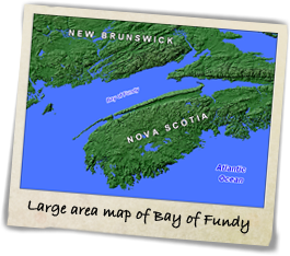
Look closely at the map on the SuperGraphic. Can you see the "bathtub" shape of the Bay of Fundy? The bay has been dubbed the "World's Largest Bathtub" for two reasons: 1. Its bathtub shape, and 2. The effect of the water rushing in through the narrow channel. The resulting tidal action compares to the wave action produced by a child sloshing water back and forth in a bathtub. Like the water in a bathtub, each wave becomes higher than the previous one. The water does not have the opportunity to spread out as it does in the broad Gulf of Mexico; instead, it splashes up higher. Just like in your bathtub, the water is confined to the area and must splash upwards and sometimes spill over!
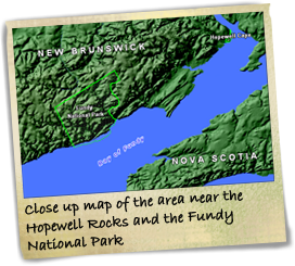
Now let's take a closer look at this bathtub-shaped bay. The bay is bordered by New Brunswick on its northwest side and Nova Scotia on its southeast side. The Bay of Fundy is 290 kilometers (180 miles) long. The mouth of the bay is 100 kilometers (62 miles) wide and between 120 and 215 meters (400-700 feet) deep. From the mouth of the bay to the head of the bay, the body of water gradually narrows. The water from the Atlantic Ocean enters the bay at the wide end of the mouth and funnels toward the narrow end of the Bay of Fundy.
Narrowing yet again, the water divides to form Chignecto Bay to the north and the Minas Basin to the south. Tapering further, Chignecto Bay splits into Shepody Bay and Cumberland Basin. Growing shallower still, Shepody Bay tapers and becomes the mouths of two rivers: the Memramcook and the Petitcodiac. It is this continual funneling and shallowing that gradually constricts the tidal flow. A constricted tidal flow alone, though, is not what causes the highest tides.
Let's look at one more part of the picture. The exact dimension of this basin of water is another important factor. The bay's relatively short length causes the water to "splash up" as the tide quickly comes in. The time it takes for the tide to come into the bay is almost identical to the time it takes to flood the whole length of the Bay of Fundy. And what a splash of high tides that creates! You know what happens next. Picture your bathtub. Sometimes the water must spill over.
The Power of Water & Weather & Wind
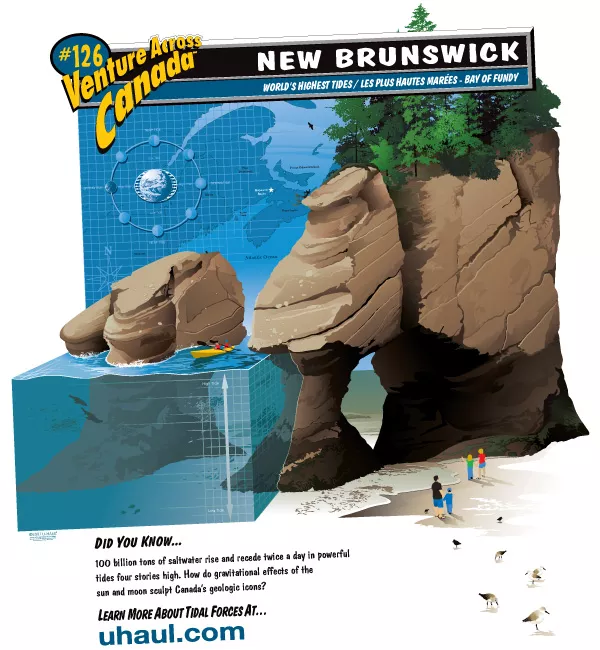
The tidal water does not just stop when it reaches a land formation. It swirls around it, tugs at it, shapes it over time. Over thousands of years, water moves rocks, chisels caves, carves canyons, contours coastlines. Tides as powerful as those found in the Bay of Fundy have, over time, helped to shape the shoreline and the land formations found there. Several coastal landforms created, in part, by wave erosion exist in the area. The rock formations you see in the SuperGraphic illustration give you a perfect picture of how rocks are shaped with a little help from high tides.
Sea cliffs, sea caves, sea arches, sea stacks – all are examples of what the sea has shaped with its surf on the shoreline. Sea cliffs are formed when waves erode and undercut rocks to make steep slopes. Waves splash at the base of a cliff and continue to wear away the rock and make the cliff ever steeper. How quickly the sea cliff erodes depends on the power of the waves and the hardness of the rock. Hard rocks, such as granite, erode more slowly than soft rocks, such as shale.
Sea caves are formed when the waves dig large holes into weaker rocks – often along the base of sea cliffs. Sea arches form when the tidal action keeps eroding a sea cave even further – completely cutting an arch through the rock. And stacking up to be one of the most impressive displays of water erosion is the sea stack. Sea stacks are columns of rock that were once connected to the mainland, but are now standing alone. The waves over time have so eroded the shoreline, that they have left stacks of harder rocks completely isolated from the main body of land.
No discussion of water erosion would be complete without mentioning the eroding power of weathering as well. Weathering is the process by which rock materials are broken down. In the Bay of Fundy, erosion by weathering plays as an important part in shaping the shoreline. The powerful forces of water, wind, gravity, ice, plants and animals are all agents of mechanical weathering. Not one of these special agents works alone.
In the Bay of Fundy, near the coast of the North Atlantic Ocean, water, weather and wind are strong, abrasive agents in the shaping of the coastline. Known for its extremely cold temperatures and often-biting winds, the North Atlantic area has all of these special agents hard at work. The alternate freezing and thawing action found here is one form of mechanical weathering. During warm weather, water seeps into cracks in the rocks. When the temperatures become colder, the water freezes into ice and expands. The ice then pushes against the sides of the crack and causes it to widen.
There may no better place on Earth to see examples of the powerful sculpting action of weathering and high tides than in the Bay of Fundy. The rock formations you see in the SuperGraphic actually exists and these geologic icons are known as the Hopewell Rocks.
Hopewell Rocks
Robert Ripley of "Ripley's Believe It Or Not" fame is believed to have dubbed the rock formations "flowerpot rocks" during his visit to Hopewell Cape in the late 1930's. With trees and foliage at the top of large "pot-shaped" rock formations, it's easy to see why the sea stacks remind people of flowerpots.
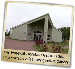
Hopewell Cape, New Brunswick, hosts visitors from around the world who are eager to explore the fascinating ecosystem found in and around the Bay of Fundy. The Hopewell Rocks Ocean Tidal Exploration Site is a worthy starting point in the area. The interpretive center, located on site, gives visitors an opportunity to learn more about the tides, geology, nature and human history of the area. The visitors who best appreciate the dramatic tidal ranges view the tides when they are low and again when they are high. Strolling throughout a network of trails and viewing platforms, exploring the shoreline and learning about the marine, animal and avian life of the bay are rewarding ways to spend time between the ebb and flow of the tides.